Continued thread

Even on the Queensland page of the @ABC "NEWS" website, it has this...the last report was 11 hours ago.
#CycloneJasper


Even on the Queensland page of the @ABC "NEWS" website, it has this...the last report was 11 hours ago.
#CycloneJasper
The sun sets on Tropical Cyclone #Jasper over Cape York Peninsula, Australia. Current wind speed more than 110 km/h.
Today’s view of Tropical Cyclone #Jasper near Cape York Peninsula, Australia. Wind speed over 110 km/h.
Buy bananas today! Remember Cyclone Yasi ...
#CycloneJasper
Cyclone Jasper is hitting the coast of Far North Queensland.
It's currently a category one weather system, with a chance it could intensify to a category two. (It got up to cat 4 then tapered off I believe)
Landfall is expected later this afternoon (Australian Eastern Time - Queensland time).
Could be around Port Douglas - between Cairns and Cooktown.
Images from BoM and earth.nullschool.net
1/2


#CycloneJasper will make landfall late on Wednesday (local time) between Hope Vale and Cairns, Queensland, #Australia.
The slow-moving cyclone will produce heavy rain in the vicinity of #Cairns, which will increase the risk of localized flash flooding overnight into Thursday.
#Jasper is now a Category 2 Tropical Cyclone with maximum winds of 110 km/h. Landfall expected tomorrow (Wednesday) north of Cairns. Strong winds will affect the coast overnight. #CycloneJasper
Latest satellite + radar:
Sunset on Tropical Cyclone #Jasper near Cape York Peninsula, Australia. Maximum wind speeds over 110 km/h.
Tropical Cyclone #Jasper satellite view from today near Cape York Peninsula, Australia. Current wind speed over 100 km/h.
#CycloneJasper is steadily strengthening this morning east of Cape York Peninsula, #Australia 

#Jasper is currently forecast to become a Category 2 Tropical Cyclone (on the Australian scale) and make landfall between Cooktown and Cairns on Wednesday afternoon.
#CycloneJasper is forecast to reintensify as it approaches the northern coastline of Queensland, Australia 
Jasper will most likely make landfall somewhere between Cape Flattery and Cardwell. This animation of wind gusts using the latest ICON model run shows Jasper striking #Cairns on Wednesday:
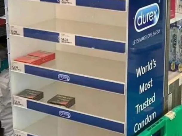
Shelves stripped bare as Queensland prepares for tropical cyclone #Jasper.
This evening’s satellite picture of Tropical Cyclone #Jasper in the Coral Sea. Winds exceeding 100 km/h.
Today’s view of Tropical Cyclone #Jasper in the Coral Sea. Wind speed over 100 km/h.
Well then, predictions for Cyclone Jasper are getting more precise. Right now, modelling shows an almost direct hit with Cairns and Mareeba on Wednesday, category kind-of-scary.
I still expect it to divert, probably to the south, but that's based on what the last few did, not science. I am slightly more nervous than I was this morning.
#CycloneJasper #Cairns #cyclone #Mareeba


Latest satellite picture of Tropical Cyclone #Jasper in the Coral Sea. Maximum wind speeds over 110 km/h.
Just removed this cootie patootie from my face, where it landed after jumping off the garden umbrella I was trying to disassemble. I didn't even squeal. There are a few around this morning. I guess they know what's coming.
#LivingInTheTropics #TCJasper #Frog #WhiteLippedGreenTreeFrog #CycloneJasper

Night-time satellite view of Tropical Cyclone #Jasper in the Coral Sea. Maximum winds of 130 km/h.
This evening’s satellite view of Severe Tropical Cyclone #Jasper in the Coral Sea. Winds reaching 150 km/h, pressure 970 hPa.
Severe Tropical Cyclone #Jasper satellite picture from today in the Coral Sea. Maximum wind speeds over 165 km/h, pressure 964 hPa.