Mina<p>We all know, how crappy the common <a href="https://berlin.social/tags/Mercator" class="mention hashtag" rel="nofollow noopener" target="_blank">#<span>Mercator</span></a> projection for world <a href="https://berlin.social/tags/maps" class="mention hashtag" rel="nofollow noopener" target="_blank">#<span>maps</span></a> represents areas, inflating them with distance from the equator.</p><p>What many people don't know, is why this projection is still so popular: </p><p>The shortest path between two points on the globe, is a straight line on the map.</p><p>I reckon, this is useful.</p><p>In all other projections, the shortest paths are curves. </p><p>In <a href="https://berlin.social/tags/Maths" class="mention hashtag" rel="nofollow noopener" target="_blank">#<span>Maths</span></a>, we say, the Mercator projection preserves angles, not areas.</p>

#mercator
0 posts0 participants0 posts today
Happy birthday to Gerardus Mercator (1512-1594) renown Flemish cartographer.
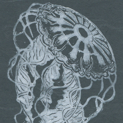
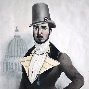
What made Mercator a great #cartographer, was in fact his abilities as a #mathematician -and like those of us scientists who feel compelled also to create art he was wasn’t hindered by his immense ability as an engraver. He produced beautiful world maps (a version of which is depicted in this print), globes,  1/n
1/n

 Greg Cocks
 Mercator Misconceptions - Clever Map Shows the True Size of Countries [Especially In High Latitudes]
--
https://www.visualcapitalist.com/mercator-map-true-size-of-countries/ <-- shared technical article
--
https://equal-earth.com/ <-- shared Equal Earth map projection details [the poster’s recommended global projection for many use cases]
--
[note the ‘true’ size of high latitude landmasses like Greenland and Canada (and Russia as well); note also that the Mercator Projection was not / is not a ‘tool of colonialism’, geopolitics or the like, it was/is ‘simply’ a very clever projection to aid in marine navigation]
#GIS #spatial #mapping #projection #Greenland #Canada #Russia #size #landarea #projection #mapprojection #JustSayNoToGallPeters #equalarea #Mercator #marine #nautical #navigation #spheroid #globe #area #shape #direction #equalearth #Africa #rhomb #rhomblines
Replied in thread

@tagesschau die #Landkarte ist offensichtlich völlig ungeeignet um zu zeigen, dass Grönland sechsmal so groß wie Deutschland ist. Auch der eingeblendete Maßstab gilt in hohen Breiten nicht. #Mercator ist für die Polarregionen völlig ungeeignet! @TerribleMaps
Do all gps-apps on Android use only mercator? Planning a trip in North - South direction and Mercator makes it hard to eyeball distances.
Would be handy if I could swap projections.
A #map in the #wild. Turned around this evening in the #pub #urinal (not before I’d finished!) to see this peeling #wall paint. Can you see a #Mercator northern hemisphere #global projection here? It struck me immediately!
FYI I hate Mercator projections. If I’m forced to put #north at the top of my maps, then I choose #EqualEarth projections. I disavow Mercator’s #imperialist #global view of the world. As a #medieval (ist) #East is always top of any map I draw anyway! #Orientate your #Maps.

Greenland is north, east, south and west of Iceland.
Nostalgia – Cartography & Projections On Network TV’s ‘West Wing’
--
https://youtu.be/UPaca-SrvEk?si=vhY84Z-_KopnQ083
--
Cool to see map geekiness pop up on network TV drama a few years back
--
• I am NOT a fan of the the Galls Peters - thinking that the Equal Earth Projection (https://equal-earth.com/) is vastly superior technically and ‘aesthetically pleasing’
• The 1569 Mercator projection was NOT designed as a ‘tool of cultural oppression’, that is a persistent myth - but rather was "... the standard map projection for navigation because it is unique in representing north as up and south as down everywhere while preserving local directions and shapes...”
• As a Trekkie, I also love that the actor John Billingsley - who plays Dr Flox - is the ‘lead scientist’…
#GIS #spatial #mapping #cartography #projection #mapprojections #gischat #StarTrek #WestWing #networkTV #TV #EqualEarth #mapping #representation #mapgeeks #mapgeekiness #mercator #rhumblines #navigation #usecase #marine #shape #area #distance
Replied in thread


This site is really fun :)
(Also, turns out NZ is nowhere near the same size as the UK, as is often said. Waaaay bigger. Indeed, generally bigger than even I’d realised…)
The True SizeCompare Countries With This Simple ToolDrag and drop countries around the map to compare their relative size. Is Greenland really as big as all of Africa? You may be surprised at what you find! A great tool for educators.
Replied in thread
This is a great image. It helps debunk the baseless conspiracy theory, i.e. Mercator map was meant to support racism and make Europe look bigger. In fact the biggest area distortions of the #Mercator map are #Siberia, #BaffinIsland, and #Antarctica, all of which are almost entirely unpopulated. The actual reason for this particular map projection is merely ease of early, pre modern science, ocean #navigation:
https://kaiserscience.wordpress.com/earth-science/maps/mercator-maps-use-and-criticism/
KaiserScienceMercator maps: Use and criticism
Replied in thread
Useful reminder. Though it is equally useful to remind readers that these #mercator projection #maps are not a reflection of #Eurocentrism: they were designed primarily for navigation purposes, thus not at all intended as a realistic representation of actual space
www.markmonmonier.comMark Monmonier - Rhumb Lines and Map Wars: A Social History of the Mercator ProjectionThe website of Mark Monmonier, author of "How to Lie with Maps" and other books on the societal impacts of mapping.
Replied to AB
Decolonising the World Maps. Political History
Decolonising the World Maps. Political History